
According to Portugal’s Institute for the Sea and Atmosphere (IPMA), rain is expected on the mainland until 13 November. In places it may be heavy, with thunderstorms. In Lisbon, rain changes how you get around: the steps down to the metro turn slippery, water pools at the crossing, and the way through the low ground is cut off. We look at why the city floods so regularly, which buildings are more exposed and what the authorities are doing to carry the water away. And why the wet stone paving is so slippery, and why it is still there.
Why don’t the hills protect the city from flooding?
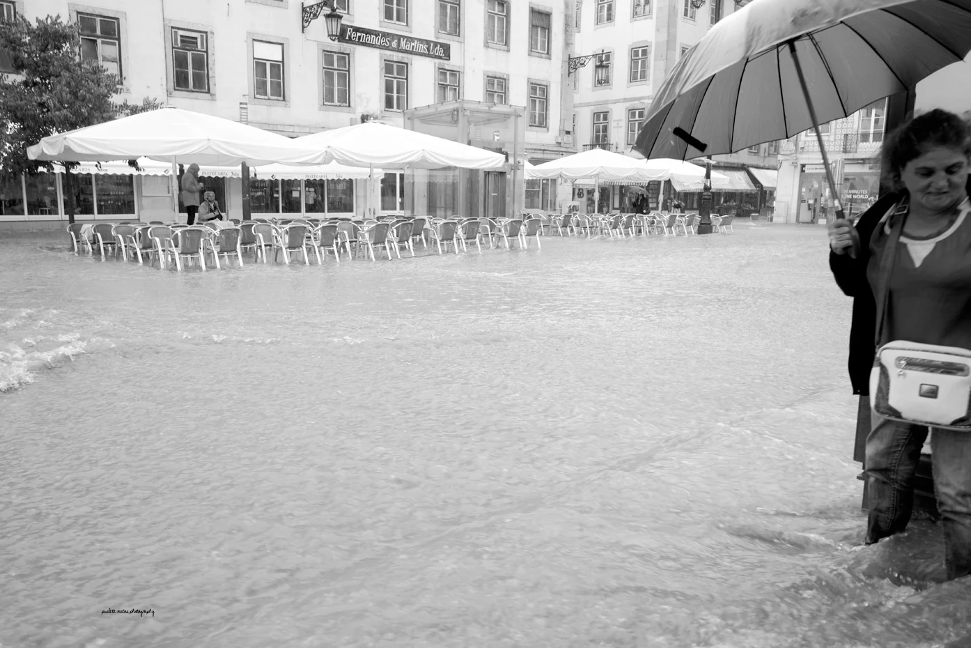
Between Lisbon’s hills lie valleys. In a downpour, water runs down the slopes and collects at the bottom. So on high ground the rain may feel ordinary, while a few blocks away it is already flooding the street. The low-lying parts of Baixa, Alcântara and the Tagus riverfront are especially exposed.
Some of the rainwater once soaked into the ground. Today much of the surface is taken up by roofs, asphalt and other hard surfaces. Water reaches the streets faster, and from there it has to drain through gratings into the underground network. If the rain brings more water than the system can carry away, it builds up on the surface.
Leaves and litter clogging a grating can make things worse. But cleaning only solves part of the problem: the sewers also have a limit to how much they can carry. On top of that, drainage near the river becomes harder at high tide. So the same downpour can have different consequences depending on whether the drains are clear and how high the Tagus is.
Which rivers are hidden under the streets?
Today’s valleys were once the beds of small rivers and streams. As the city grew, they were covered over, channelled and folded into the drainage system.
Valverde — near Avenida da Liberdade. Its bed ran along the line of today’s Rua de Santa Marta and Rua de São José, next to the avenue. From there the water flowed on towards Baixa and the Tagus.
Arroios — the Avenida Almirante Reis valley. Another stream ran here, also known as the Regueirão dos Anjos. Its valley led towards the centre through what is now Martim Moniz. The very name Arroios recalls the streams that once flowed through the area.
Alcântara — from Amadora to the Tagus. Along this river people washed laundry, grew vegetables and ran businesses. At the same time, the city’s waste water flowed into it. Over time the sanitation problem became one of the reasons to close the riverbed.
Some stretches were covered as early as the 19th century. The main works on the Caneiro de Alcântara culvert took place between 1945 and 1967. Today it carries household waste water and rainwater from a large part of the city. In normal conditions this is sent to treatment plants.
Covered riverbeds do not explain every flood on their own. But the shape of the valleys has survived, so water still heads for where the old streams once ran. Development changed how the water drains, but the low ground is still there.
How to check your area and your building
Baixa, Alcântara, Almirante Reis and Avenida da Liberdade come up again and again in the city’s flood history. There are other exposed spots too: Sete Rios, parts of Benfica and the low-lying stretches along the Tagus. But the name of a neighbourhood is too broad to judge a particular flat. On the same street, entrances can sit at different heights.
The municipal map Lisboa Interativa has a layer called Vulnerabilidade às Inundações — “vulnerability to flooding”. It marks three levels of vulnerability: moderate, high and very high. You can use them to compare addresses when choosing a flat or to assess the area around your home. A high level is a reason to find out in advance how the building is protected from water.
For a street-level flat, the entrance, the basement windows and the ramp down to the garage matter most. It is worth asking the neighbours or the building manager how high the water rose in earlier downpours. What was repaired afterwards, and did it help? The map shows how exposed an area is in general; for a particular building, its own flood history tells you the rest.
Why are giant tunnels being dug under the city?
The main flood-protection project is called the Plano Geral de Drenagem de Lisboa — Lisbon’s General Drainage Plan. Its most visible part is two large underground tunnels. One links the Monsanto and Campolide area with Santa Apolónia. The second runs between Chelas and Beato.
Each has an internal diameter of 5.5 metres — roughly the height of a two-storey house. Their job is to take the overflow and carry it to the Tagus along an additional route. For the first tunnel, inlets are planned near Avenida da Liberdade, Santa Marta and Almirante Reis. That way part of the load should leave the existing network before the low-lying areas overflow.
In July 2025 Lisbon City Council announced that boring of the first tunnel was complete. It is an important milestone, but on its own it does not mean the whole system is running. Connections, intake structures and the remaining works are still needed. In the project’s published schedule, some sites of the first tunnel remain under construction until 2027. Part of the second tunnel’s works is not due until 2029. So you cannot count on the new tunnels removing the risk of flooding this autumn.
The plan also includes other measures: upgrading the network, holding rainwater back and letting it soak into the ground. For example, shallow depressions in parks and green spaces take in part of the runoff and slow down how fast it reaches the sewers. Streets need both faster drainage and room to store water for a while.
The water-collection areas in Parque Gonçalo Ribeiro Telles at Praça de Espanha already do this. The municipal LIFE LUNGS project cites them as an example of holding back and absorbing rainwater. During rain they help take pressure off the underground network. But their capacity is limited, so they work alongside the tunnels, not instead of them.
Why is the stone paving so slippery?
Flooding is not the only problem when it rains. Even where the water drains quickly, you can slip on the wet pavement.
The familiar black-and-white calçada portuguesa is made of small stones. The white stones are usually limestone, which wears smooth under pedestrians’ feet and loses grip when wet. On a slope, keeping your balance gets harder still.
The paving spread through city council decisions in the 19th century. Local limestone was easy to get, and stone patterns decorated the squares. In 1895 the city council made calçada the required surface for pavements and squares.
Today decorative calçada is part of Lisbon’s look. The craft of making it is listed in Portugal’s national inventory of intangible cultural heritage. When streets are repaired, preserving this heritage has to be balanced against pedestrian safety.
The paving can be made less slippery when it is relaid: by changing the mix of stone and levelling the surface. In Mouraria, on Rua de São Cristóvão, a mix of limestone and granite has already been used.
In October 2026 the Santa Maria Maior parish council announced a phased repair of worn pavements. On these stretches the paving is taken up and the base is prepared again. Stones still in good condition are reused to keep the streets’ traditional look.
Why does rain disrupt public transport?
If a street floods, it may be closed to traffic. Buses are then diverted or services are temporarily cancelled. Trams may be stopped if water covers a stretch of track.
Bad weather can also break the connection between the metro and the train. On 13 December 2022, for example, access from Entre Campos station to CP trains was closed. In such cases you have to change your route even if the metro line itself is running.
On the Tagus, ferry crossings may be cancelled because of bad weather and rough water. Sometimes the schedule changes too. The operator Transtejo/Soflusa (TTSL), for example, has warned that some boats on the Cacilhas — Cais do Sodré line would depart only when full. In that mode, departure times may not match the timetable.
The old riverbeds are hidden under the streets, but the water still gathers in the same valleys. The new tunnels are meant to give it an extra route to the Tagus and reduce the risk of flooding on the surface.